
Google Earth Image Generation Removed After Just One Day
After integrating Nano Banana 2, Google Earth allowed users to alter imagery of real-world locations using text prompts. However, after users generated fabricated scenes depicting refugee camps, explosions, and nuclear facilities, Google removed the feature in less than 24 hours.
Google Earth had barely added generative AI to its satellite maps before removing it less than 24 hours later.
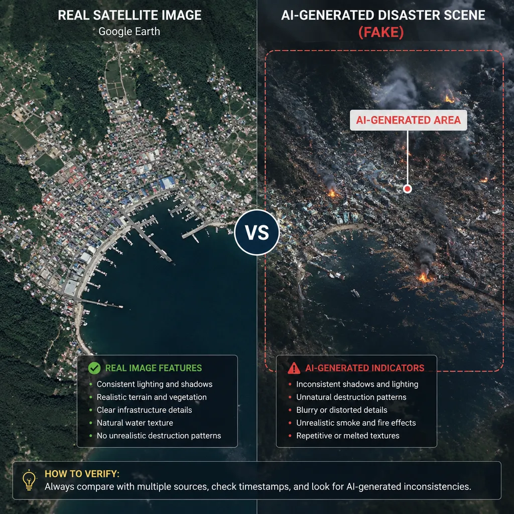
As of August 1, Google has withdrawn the Nano Banana 2-powered AI image editing feature from Google Earth. The feature allowed users to select a real location and alter its satellite, aerial, or 3D imagery through text prompts. It was originally positioned as a tool for historical reconstruction, real estate planning, and creative visualization, but soon after launch, it was used to create highly sensitive fabricated geospatial images depicting refugee camps, blast craters, changes at nuclear facilities, and more.
Google's explanation was straightforward: some shared outputs appeared to violate its policies. The feature has been temporarily taken offline until stricter safeguards can be established.
What truly deserves attention in this incident is not that users once again "jailbroke" an image model, but that Google placed generative capabilities inside a product that has long served as a factual reference. Conventional AI image generators create content on a blank canvas. Image generation in Google Earth, by contrast, modifies content tied to real-world coordinates, actual terrain, and satellite imagery. The two may use similar models, but the societal risks they create are on entirely different scales.
From a Historical Reconstruction Tool to a "Geospatial Deepfake" Button
The feature Google Earth added was called "Create Image." Users could locate an area in the web version, enter a prompt, and Nano Banana 2 would use the current satellite, aerial, or 3D map data as a visual anchor to generate a new scene consistent with the real terrain.
Based on product demonstrations, this capability was genuinely useful. Teachers, for example, could restore the ruins of Pompeii to their first-century appearance; film crews could preview how a city square might look with a futuristic set; and real estate and urban planning professionals could simulate landscapes after changes to buildings, greenery, or roads.
The problem was that the same input box could also be used to generate entirely different kinds of content.
Digital investigations researcher Henk van Ess found during testing that the tool could add refugee camps, signs of explosions, and other sensitive subjects to real locations. Public reports cited scenarios involving refugees near the U.S.-Mexico border, Iranian nuclear facilities, and craters near a hospital in Gaza. Other tests involved explosions in Paris, craters inside Russia, and suspicious warehouses.
These images were not genuine satellite observations, yet they inherited the most persuasive elements of the real basemap: accurate road layouts, building outlines, terrain textures, and geographic coordinates. The model needed to alter only a small portion for the entire image to acquire the visual credibility of "this may be footage captured just moments ago."
That is the most dangerous aspect of this product decision. It did not merely let users draw a fictional city from scratch; it let them manufacture fictional evidence at a real location.
Watermarks Cannot Solve Screenshot-Based Distribution
Google initially responded that generated images carried digital watermarks and that the system would block harmful topics. After withdrawing the feature, Google also emphasized that these AI-generated images had not been added to the publicly viewable content in Google Earth.
Both points matter, but neither adequately addresses the real-world distribution risk.
First, keeping generated images out of the public map only means that Google Earth's shared basemap was not directly contaminated. It does not mean the outputs could not leave the product. Users could download images or take screenshots, crop, compress, or edit them further before posting them to social media platforms, group chats, and news comment sections. Most people who encounter such an image will not return to Google Earth to verify how it was created, much less know that it originally appeared inside an AI editing interface.
Second, watermarks function more like a post hoc forensic mechanism than a preventive safety measure. Whether they are visible labels or invisible SynthID watermarks, platforms, media organizations, or verification personnel must actively check for them. Screenshots, photos taken of a screen, partial crops, and repeated compression can also make detection more difficult.
That level of friction may be acceptable for ordinary entertainment images. For war zones, borders, nuclear facilities, and disaster scenes, however, the window for making a judgment is often only a few minutes. Even if a fake satellite image is eventually debunked, it may already have triggered market volatility, public panic, or misguided decisions. In 2023, an AI-generated fake image of an "explosion at the Pentagon" affected financial market sentiment within a very short period.
In other words, proving that "an image can eventually be identified as AI-generated" is not the same as proving that "the image can be identified before it causes harm."
Why the Safety Filters Failed to Stop It
The test results suggest that Nano Banana 2 was not entirely without safety policies. The problem more likely lay in gaps between policy coverage, contextual recognition, and product permission design.
Traditional image-model moderation generally focuses on prompts and final outputs, blocking explicitly violent, illegal, or hateful content, for example. But the risks of geospatial imagery depend heavily on location and context. A request to "add smoke and damaged buildings" may be nothing more than concept art on a fictional game map. Place the same elements next to a real hospital, nuclear power plant, or border crossing, however, and the image may be interpreted as depicting an ongoing event.
This requires the safety system to understand at least four categories of information simultaneously:
- What the user has requested;
- Which real-world location the image represents;
- Whether that location is a sensitive military, energy, medical, or political facility;
- Whether the generated output can be exported and circulated without its original AI labeling.
A keyword blacklist alone is poorly suited to this task. Users can bypass filters through metaphors, multi-step edits, or seemingly neutral descriptions, while the model may not reliably recognize that an unremarkable-looking building is actually critical infrastructure.
A more reasonable solution would be to establish firm boundaries around the product's capabilities rather than continuing to pile on prompt rules. Generative editing could be disabled for hospitals, nuclear facilities, military bases, government buildings, and conflict zones. Edits involving disasters, explosions, mass displacement, or infrastructure damage could be denied by default. High-resolution downloads could be restricted. Visible labels that are difficult to crop out could be placed over the main subject of the image. The system could also retain provenance, prompts, and editing histories to create verifiable content credentials.
This would sacrifice some of the "generate anything" experience, but a geospatial information tool should never prioritize generative freedom over trustworthiness.
Google Earth Is Not an Ordinary Creative Tool
Google's investment in geospatial AI extends far beyond this image-generation feature. Earth AI is seeking to combine satellite imagery, weather, population, and environmental models for flood warnings, infrastructure detection, urban planning, and disaster response. Its core value lies in turning the planet into a searchable, analyzable, and reasoned-over data object.
Within this domain, analyzing the real world and generating a fictional one are product directions that point in opposite directions.
The former helps users identify flooded roads, new construction sites, or power infrastructure across thousands of remote-sensing images, with the goal of lowering the cost of understanding reality. The latter lets users alter the object being observed, with the goal of improving the efficiency of creative expression. If both capabilities share the same map interface without sufficiently clear separation between modes, users can easily confuse "what the model discovered" with "what the model drew."
This is also why Google Earth must exercise greater caution than an ordinary image editor. Over more than two decades, it has become one of the public's primary gateways to satellite imagery, as well as an important reference for journalists, researchers, and the open-source intelligence community when verifying events in remote areas. The brand and interface themselves serve as a form of trust endorsement.
An image featuring Google Earth's map style, real coordinates, and familiar terrain is more likely to be believed than an ordinary AI-generated image, even without official Google branding. Google effectively embedded creative capabilities inside an evidentiary tool while continuing to apply the safety model of a consumer-grade image generator.
This is a product architecture problem, not merely a matter of the model's refusal rate.
Withdrawal in Less Than a Day Reveals a Broken Release Process
Google made the right choice by quickly taking the feature offline. But the fact that such obvious abuse scenarios were not exposed until after the public launch indicates that internal red-team testing and release reviews were not commensurate with the product's risks.
Refugee camps, explosions, hospitals, borders, and nuclear facilities are not obscure attack vectors. They should be among the first scenarios tested for any geospatial image generation tool. As soon as a product allows users to modify real locations, the team should assume that someone will use it to fabricate wars, disasters, military movements, and infrastructure accidents, rather than waiting for researchers to post screenshots on social media before adding safeguards.
A "launch first and see how users abuse it later" approach might be defended as rapid iteration in an ordinary consumer application. On a platform that controls access to highly trusted data, however, it amounts to shifting the cost of safety testing onto the public.
This problem is not unique to Google. In July, Meta launched Muse Image, which allowed users to generate content based on images from adult users' public Instagram accounts unless the account owners proactively opted out. The feature was withdrawn in less than a week, with Meta acknowledging that the experiment had "missed the mark." The common thread between the two incidents is that companies directly connected high-value real-world data already present on their platforms—geospatial imagery or photographs of real people—to generative models, while underestimating the trust and rights risks arising from the data's original context.
The Real Boundary Lies at the Product Layer, Not Just the Model Layer
Generative models will inevitably continue to enter maps, Street View, remote sensing, and urban digital twin systems because the demand is real. Historical reconstruction, architectural previews, disaster simulations, and film location scouting can all benefit from these capabilities. An outright ban is not the answer.
But Google Earth's decision to launch and then withdraw the feature within a day has at least drawn a clear line for the industry: when generated content is attached to real coordinates and trusted data sources, the safety standard must be higher than for ordinary AI image generation.
If the next version of the feature is relaunched, Google will need to make changes at no fewer than three levels:
- Model layer: The moderation system must understand prompts, generated outputs, and the semantics of locations simultaneously, rather than merely matching sensitive keywords.
- Product layer: Hard restrictions must be placed on sensitive areas, sensitive edit types, and export capabilities, while the AI-generated status must remain visible at all times.
- Distribution layer: Verifiable provenance credentials and public detection tools must be provided so that media organizations, platforms, and researchers can quickly authenticate screenshots.
From a developer's perspective, this is also a practical reminder: connecting a model to real-world data is not merely a matter of adding a retrieval interface or image-conditioning input. The more authoritative the data source, the more trust the generated output inherits. The more a product resembles a professional tool, the stronger the user's default expectation that its outputs are authentic.
Nano Banana 2 demonstrated powerful scene-integration capabilities in this incident. Indeed, it was precisely because the generation quality was so high that the problem escalated so quickly. What Google lacked was not a stronger image model, but a release process commensurate with Google Earth's influence.
Withdrawing the feature after one day prevented it from spreading further. But for Google Earth, what truly needs repair is not an image-generation button. It is the boundary—one that should have been unmistakably clear—between analyzing reality and manufacturing it.
References
- ITHome: Google Earth's AI image-generation feature removed less than a day after launch for generating unrestricted "disaster" images — Reports on the feature's removal, researchers' test results, and Google's official response.