
WeatherNext Extends Cyclone Forecast Lead Time by One Day
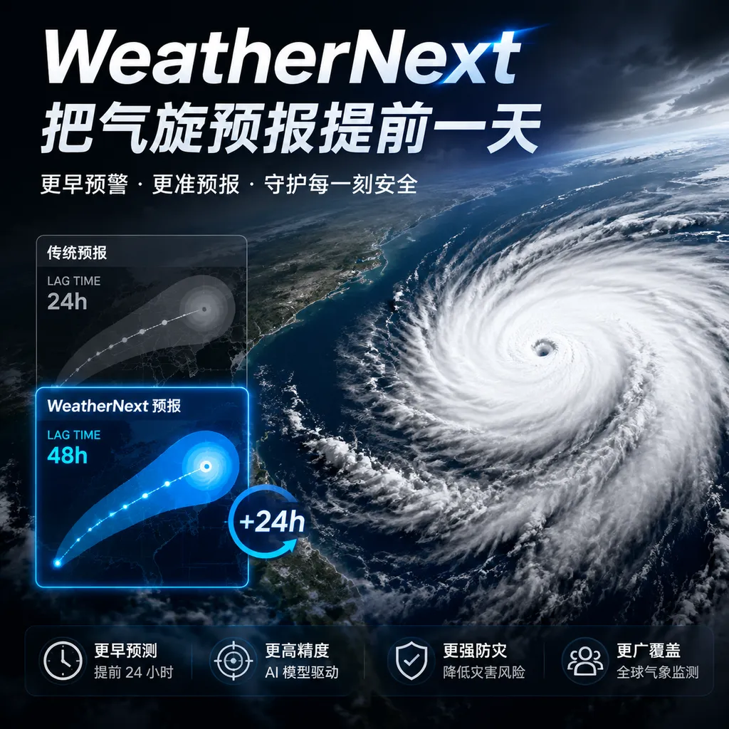
Google DeepMind recently unveiled new advances in WeatherNext’s tropical cyclone forecasting: its storm-track predictions made three days in advance are now as accurate as traditional methods’ two-day forecasts. What truly deserves attention is that AI is beginning to generate probabilistic scenarios that can inform risk decisions, rather than merely producing a single seemingly precise track.
AI Weather Models Are Taking On the Hardest Storms to Predict
Google DeepMind recently announced the latest advances in WeatherNext’s tropical cyclone forecasting capabilities. Test results show that its accuracy in predicting hurricane tracks three days in advance now matches the level that previous methods achieved with two-day forecasts. Put simply, AI has gained roughly 24 additional hours for storm-track warnings.
Do not underestimate the value of that extra day.
For an ordinary weather app, one day may simply determine whether people bring an umbrella for the weekend. For cyclone warnings, it means ports can dispatch vessels earlier, power grids can conduct another round of load planning and emergency repair preparations, airlines have time to reroute flights, and coastal areas can organize evacuations more effectively.
The significance of this advance goes beyond simply making traditional numerical weather prediction faster. What WeatherNext truly changes is how forecasts are delivered: rather than providing only a single “most likely track,” it can rapidly generate hundreds of correlated, physically plausible future weather scenarios from the same initial atmospheric state.
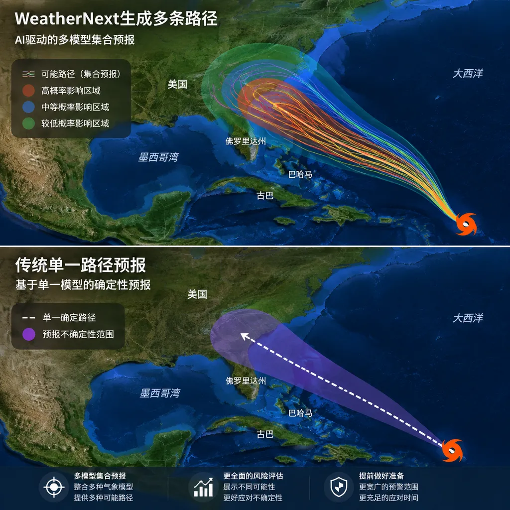
From a product perspective, this matters far more than merely improving an accuracy metric. Cyclone forecasting is fundamentally not about guessing a single coordinate, but about answering a set of risk-related questions: Where might the storm go? How likely is it to change direction? Which areas might enter the zone of damaging winds? And just how bad could the worst-case scenario be?
What Does “Three Days Ahead Equals Two Days Ahead” Actually Mean?
The core result disclosed by Google is that WeatherNext’s tropical cyclone track forecasts issued three days in advance can match the error levels achieved by previous forecasting systems at a two-day lead time.
This statement can easily be misread as meaning that “the model can only forecast three days ahead.” In fact, it means the opposite: under the same error threshold, WeatherNext can provide a useful track forecast one day earlier. It is not simply extending the forecast horizon from two days to three; it is shifting the entire error curve forward.
Cyclone-track prediction can be compared to drawing a line on a chessboard moving at high speed. A tiny error in initial wind speed, humidity, or atmospheric pressure can, after several days of evolution, cause the storm center to deviate by hundreds of kilometers. The longer the forecast horizon, the greater the divergence usually becomes.
For this reason, the industry does not run a model only once. Instead, it perturbs the initial state and model processes to generate an ensemble forecast. When multiple tracks cluster tightly together, the model is relatively confident about the storm’s direction. When they diverge rapidly, considerable uncertainty remains about whether the storm will turn.
WeatherNext’s breakthrough lies in generating large-scale ensembles at lower computational cost while preserving plausible joint relationships among different variables. It does not mechanically output hundreds of unrelated weather maps; it attempts to construct hundreds of complete, coherent “possible worlds.”
This distinction is crucial. For example:
- When the storm center moves westward, the surrounding wind field, pressure, and precipitation patterns should change accordingly;
- Areas of high temperature should not clearly conflict with variables such as humidity and cloud cover;
- The power-generation risk for a wind farm cannot be assessed solely from the average wind speed at a single grid point; it must also account for how the wind field changes across the entire region;
- When a cyclone’s track shifts, wave heights, precipitation, and the probability of damaging winds in the affected waters must shift with it.
If these variables are inconsistent with one another, adding more ensemble members merely creates a pile of random samples that cannot support decision-making.
FGN: Putting Randomness Into the Model Rather Than Sprinkling Noise Onto the Results
The key method behind WeatherNext 2 is the Functional Generative Network, or FGN. Its approach is to inject noise directly into the model architecture, allowing the model to learn how that noise should map to different but plausible forms of weather evolution.
This is not the same as the common practice of first calculating a forecast and then randomly adding small deviations to the result.
The latter is like photocopying the same map and arbitrarily moving the cyclone center a few grid cells. FGN is closer to having the model simulate atmospheric evolution multiple times from scratch. Each simulation may produce a different track, but the track, wind field, temperature, humidity, and atmospheric pressure still belong to the same weather scenario.
Technically, this addresses the problem of joint distributions.
Traditional deterministic models tend to predict the average or most likely value of each variable at each location, but they do not necessarily represent the probability of multiple variables occurring together. For consumer weather applications, averages may sometimes be sufficient. For energy, shipping, and disaster management, however, averages can obscure the risks that truly matter.
Suppose a port faces two main scenarios over the next three days:
- The cyclone turns north, leaving the port largely unaffected;
- The cyclone continues westward, exposing the port to damaging winds and heavy rain.
If the two scenarios are simply averaged, the system may predict “moderate winds and moderate rainfall.” In reality, this compromise scenario may never occur. What decision-makers truly need to know is how likely the second scenario is and how much they should spend to prepare for it.
The value of generative ensemble forecasting lies precisely in preserving this kind of multimodal, asymmetric, and correlated uncertainty.
Greater Speed Is Not Just About Saving Compute
WeatherNext 2 can generate hundreds of possible weather outcomes from a single starting point. According to Google, one forecast takes less than a minute on a single TPU, whereas traditional supercomputer-based ensemble forecasts generally require several hours. Compared with the previous generation, the new system generates forecasts approximately eight times faster and can provide hourly outputs.
Why can AI weather models operate so much faster?
Traditional numerical weather prediction requires discretizing the equations of atmospheric dynamics onto a three-dimensional grid, then calculating step by step how variables such as pressure, temperature, wind, and humidity evolve. It is more like a high-precision physics simulator: computationally robust, but extremely expensive.
Models such as WeatherNext instead learn patterns of atmospheric evolution from large volumes of historical reanalysis data and weather states. During inference, they no longer solve the full set of physical equations from scratch, but use neural networks to predict future weather states directly. One way to understand this is that traditional methods repeat a complex derivation for every forecast, while AI models compress much of that derivation into their parameters and then produce results rapidly.
Speed, however, is not merely an infrastructure metric. For cyclone forecasting, it determines whether a system can:
- Rerun quickly after the latest observational data arrive;
- Generate enough ensemble members to cover low-probability, high-loss events;
- Perform sensitivity analyses for different initial conditions and risk assumptions;
- Deliver results promptly to shipping, power-grid, insurance, and emergency-response systems;
- Provide higher-frequency forecasting services in regions with limited computing resources.
Only when each forecast becomes cheap enough to complete within minutes can a model evolve from a research demonstration into infrastructure that can be called repeatedly.
WeatherNext Is Not a New Model That Appeared Out of Nowhere
Strictly speaking, this development is better understood as an expansion of WeatherNext’s capabilities rather than the release of an entirely new model with no predecessor.
Google previously launched WeatherNext Gen and its successor, WeatherNext 2. The former is a diffusion-based global medium-range ensemble weather forecasting system covering variables such as temperature, wind, precipitation, humidity, geopotential, sea-surface temperature, vertical velocity, and atmospheric pressure. It has a spatial resolution of 0.25 degrees and a maximum forecast horizon of 15 days.
WeatherNext 2 further improves speed, temporal resolution, and multivariable joint forecasting. Google previously stated that it can predict temperature, atmospheric pressure, and wind more accurately over the next two weeks, and that it plans to integrate these capabilities into products such as Search, Gemini, and Maps. Its data are also available through developer and data-analysis platforms such as Earth Engine and BigQuery.
As of August 2026, developers also need to pay attention to a practical migration issue: the legacy WeatherNext Gen dataset reached its scheduled deprecation date on July 15, and Google requires existing workflows to migrate to WeatherNext 2. Records through late July remained temporarily accessible in the old Earth Engine catalog, but being able to read historical assets does not mean the APIs and production workflows will continue to receive stable maintenance.
If a business depends on the legacy ImageCollection, field names, initialization cycles, or 12-hour forecast steps, it should now verify:
- Whether the dataset asset ID has been updated;
- Whether WeatherNext 2 changes the definitions of variables, units, or dimensions;
- Whether downstream raster resampling and regional aggregation remain correct;
- Whether legacy backtesting results can be compared directly with the new version;
- Whether caching, alerting, and missing-data fallback logic cover the data migration window.
In meteorological data engineering, model accuracy upgrades are often not the most troublesome part. Changes to the data schema and breaks in historical baselines are.
Track Forecasts Have Improved Significantly, but Intensity Remains Difficult
WeatherNext deserves recognition, but it has not solved every problem in cyclone forecasting.
Tropical cyclone forecasting generally involves three related tasks of differing difficulty:
- Track: Where the storm center will move in the future;
- Intensity: How the maximum sustained wind speed and minimum central pressure will change;
- Structure and impacts: The size of the wind field and the areas exposed to rainfall and storm-surge risks.
In recent years, AI models have improved most rapidly in forecasting large-scale circulation and storm tracks because these signals are relatively continuous in global reanalysis datasets and are easier for models with coarser resolution to capture. Intensity and rapid intensification are more difficult. They are affected by processes such as ocean heat content, eyewall structure, vertical wind shear, and localized convection, which often require higher spatial resolution.
This is also an important boundary to maintain when evaluating the “breakthrough.” Matching the two-day track accuracy of traditional methods with a three-day forecast is highly useful, but it does not directly imply that warnings for landfall intensity, extreme precipitation, and storm surge have also improved by a full day.
Google has previously acknowledged that the model still struggles with extreme rain and snowfall, partly because relevant observations are too sparse in the training data. Generative models can better represent uncertainty, but they cannot conjure up extreme processes that have never been reliably observed and recorded.
AI weather models also depend on traditional observation systems and reanalysis data. Satellites, radar, buoys, weather balloons, and conventional numerical models still provide their initial states and training benchmarks. It is too early to describe AI models as replacements for traditional meteorological systems. A more realistic path is to run AI ensemble forecasts alongside numerical models, with professional organizations handling calibration, comparison, and expert interpretation.
The Real Competitive Advantage Is Integration Into Decision-Making Systems
From an industry perspective, WeatherNext is no longer merely a DeepMind research project demonstrating that AI can forecast the weather. It is becoming part of Google’s cloud data ecosystem, geospatial computing platforms, and consumer products.
This will shift the competition from “whose average error is lower?” to “who can integrate probabilistic forecasts into business operations faster?”
Energy trading organizations care about the distribution of wind speeds and solar irradiance across entire regions over the coming days. Airlines care about the probability that convective weather will affect multiple routes simultaneously. Insurers need to estimate the maximum losses associated with low-probability tracks. Logistics companies need to connect weather scenarios with ports, warehouses, and overland transportation nodes.
None of these use cases can be served by a single weather map. They require structured data that can be processed in bulk, stable update schedules, historical forecasts suitable for backtesting, and consistent relationships among variables across ensemble members. By using FGN to strengthen joint scenario forecasting, WeatherNext is targeting precisely this market.
Our assessment is that the most noteworthy aspect of this breakthrough is not that “AI is faster than supercomputers”—that is gradually becoming standard for a new generation of weather models—but that AI ensemble forecasts are beginning to provide actionable uncertainty.
A more accurate cyclone track is certainly important, but a calibrated set of possible tracks has greater commercial value. The former tells people what the model thinks will happen; the latter allows developers and decision-making systems to calculate the cost if the model is wrong.
WeatherNext has not turned cyclone forecasting into a fully solved problem. However, it has moved AI weather models beyond rapidly generating global forecasts and brought them one step closer to real-world risk-based decision-making. For coastal disaster preparedness, the additional 24 hours may provide a critical window. For developers, the next issue to watch is whether these probabilistic scenarios can be made reliably available, continuously calibrated, and integrated into production systems through sufficiently clear interfaces.
References
- WeatherBench 2: A weather forecasting evaluation framework maintained by Google Research that helps explain the benchmarking methods, variable definitions, and evaluation metrics used for AI weather models.
- GraphCast: Google DeepMind’s earlier global AI weather model and inference code, which help illustrate the technological evolution that led to WeatherNext.
The event information and performance data in this article are based on Google DeepMind’s recently published description of WeatherNext’s cyclone forecasting capabilities, Google’s developer data catalog, and public press releases. In accordance with this site’s external-link domain policy, links to domains not on the allowlist have been omitted.