
Amap Has Turned Cities into World Models

Today, Amap released ABot-Earth 0.7, aiming to connect mapping, simulation, and robot training through 3D-native urban data. Its real value lies not in generating cityscapes, but in whether it can build an interactive, verifiable model of the real world.
Amap Has Turned the City Into a World Model
On September 10, Amap, a subsidiary of Alibaba Group, officially released ABot-Earth 0.7, a 3D-native urban world model. Amap calls it the world’s first 3D-native urban world model and has further positioned the product around understanding the real world: rather than merely generating a video that looks like a city, it aims to give AI an observable, interactive urban space that can be used for training.
This update comes roughly three months after the release of ABot-Earth 0.5. Version 0.5, launched in June, had already demonstrated the ability to generate kilometer-scale 3D urban scenes from satellite imagery or text descriptions. Version 0.7 continues the same core approach: building the model directly around three-dimensional data instead of first generating 2D images and then piecing together the space through conventional modeling workflows.
This distinction may sound like technical jargon, but it effectively determines whether the model has any chance of entering serious applications such as robotics, autonomous driving, low-altitude aviation, and urban simulation.
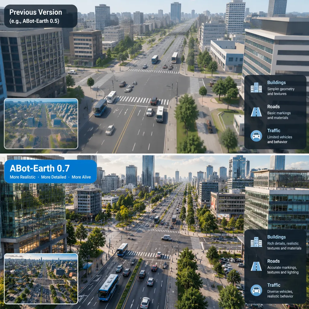
The Point Is Not to Draw a City, but to Let AI Act Within It
Over the past year, “world model” has become one of the most frequently used terms in the AI industry. Video generation models can predict the next frame, game models can generate visuals in real time based on user actions, and robotics models attempt to predict how an action will change the environment.
But cities are far more complicated than game maps.
Real cities simultaneously contain buildings, roads, slopes, trees, traffic signs, temporary obstacles, and constantly changing flows of pedestrians and vehicles. A realistic-looking image does not mean that the spatial relationships within it are correct. A road that appears visually connected does not necessarily mean that a robot can actually travel along it. For embodied AI, errors in perspective, scale drift, or missing collision relationships can all render simulation training meaningless.
The 3D-native approach emphasized by ABot-Earth means that the model handles space from the outset, rather than treating it as a byproduct of 2D imagery. Its output is not merely pixels for people to view; it must also preserve as much of the following information as possible:
- The position, size, and orientation of objects in three-dimensional space;
- The topological relationships among roads, buildings, and public infrastructure;
- Geometry and appearance that remain relatively consistent across different viewpoints;
- Scene assets that can be loaded, edited, and manipulated in rendering engines;
- Traversability, occlusion, and collision information needed for robot training.
This is also the most fundamental dividing line between an urban world model and an ordinary text-to-video model. The latter is more like a director skilled at drawing storyboards, while the former must simultaneously perform the work of a surveyor, scene engineer, and simulation system.
From 0.5 to 0.7, Amap Wants to Fill the Layer Between Maps and Robots
ABot-Earth 0.5 was released in June this year. According to information previously disclosed by Amap, that version had already created 3D maps covering more than 190 countries and regions. It could also generate kilometer-scale 3D urban scenes from a satellite image or text description in around ten minutes on a consumer-grade GPU.
Its output uses editable 3D Gaussian Splatting, or 3DGS, assets, which can be imported into mainstream engines such as Unity and Unreal Engine for further development. At the time, Amap estimated that the process could reduce the cost of 3D mapping to around one percent of that of traditional methods while improving efficiency by roughly one thousand times.
These figures are certainly eye-catching, but it should be noted that they come primarily from official statements. Traditional modeling methods encompass a variety of workflows, including oblique photogrammetry, LiDAR data collection, manual model refinement, and semantic annotation, with costs varying significantly depending on accuracy requirements. Determining exactly which baseline the claimed thousandfold efficiency improvement is measured against, and whether the generated results underwent manual correction, will require more comprehensive public testing.
What deserves more attention in version 0.7 is that Amap is shifting the product narrative from rapidly generating 3D cities to serving as a gateway for AI to understand the real world.
Map data was originally intended to solve the problem of how people find their way. In the age of robotics, the question becomes how machines understand roads, predict their environment, and act within it. Traditional high-definition maps are precise, but expensive to collect and update. Purely visual world models are flexible, but prone to errors in geometric structure and long-term consistency. ABot-Earth is attempting to position itself between the two: using Amap’s existing geospatial data as a foundation, then reducing the cost of scene creation and expansion through generative models.
If this approach succeeds, Amap will be providing more than maps or a standalone 3D generation tool. It will offer a conversion layer between real-world cities and machine-training environments.
Why Choose 3DGS Instead of Adding More Polygons?
ABot-Earth’s earlier decision to use 3DGS as a major output format is unsurprising.
Traditional games and industrial simulations rely heavily on mesh models. Developers must define vertices, faces, textures, and materials. These models have clear structures and are highly editable, but creating large-scale, realistic cities this way is extremely expensive. Neural radiance field technologies such as NeRF can reconstruct scenes from multi-view images with good visual quality, but they often suffer from slow training and inconvenient rendering and editing workflows.
3DGS represents a scene as a large number of three-dimensional Gaussian points with attributes such as position, color, scale, rotation, and opacity. Unlike traditional meshes, it does not require building a model face by face, nor does it require heavy neural-network inference for every rendering pass. This allows it to strike a more practical balance among visual quality, training speed, and real-time rendering.
For city-scale models, this representation offers three direct benefits:
- Fast reconstruction. Large volumes of real-world imagery can be converted relatively quickly into renderable scenes, making it suitable for expanding coverage.
- Relatively efficient rendering. With appropriate hardware and culling strategies, it can support real-time camera movement, bringing it closer to simulation requirements.
- Easy integration with existing engines. Output assets can be imported into Unity or Unreal Engine rather than being locked into a single research framework.
However, 3DGS is not the final destination for urban world models. It excels at representing appearance, but does not inherently understand semantics. A model may accurately reproduce the color and outline of a car without knowing that it is a movable vehicle. It may reconstruct a crosswalk without understanding the rules governing pedestrian right-of-way there.
In other words, 3DGS addresses what a city looks like. A world model must ultimately answer how the city works.
Robot Training Is Currently the Most Credible Real-World Application
Amap has already used scenes generated by ABot-Earth for city-scale simulation training and to support the training of its Tutu robots in open environments. At present, this is a more valuable direction than generating urban landscapes for consumers.
The robotics industry does not lack laboratory data. What it lacks is open-environment data that is sufficiently large in scale, varied enough, and safe enough to support repeated trial and error. A delivery robot can collect data in a business park for months, yet still encounter only a limited number of roadworks, rainwater flooding, unusual intersections, or wrong-way vehicles. Creating such long-tail events directly in the real world is expensive and may pose safety risks.
An urban world model can replicate real-world environments in a simulation system and then systematically modify their variables:
- Change the time of day, weather, and lighting conditions;
- Alter the number, speed, and trajectories of vehicles and pedestrians;
- Add roadworks, temporary barriers, or disabled vehicles;
- Adjust road materials, gradients, and visual markings;
- Run thousands of repeatable tests on the same policy.
This type of data does not necessarily require every frame to achieve cinematic visual quality, but its spatial relationships, physical constraints, and event logic must be credible. For robot training, a slightly blurry sign texture is usually not a major issue. But if the height of a step is wrong, vehicles pass through guardrails, or turning radii are distorted, the training results may be compromised.
Therefore, determining whether ABot-Earth 0.7 is genuinely useful cannot be based solely on how impressive its demo videos look. The key is whether it can narrow the gap between simulation and reality—the “sim-to-real gap,” as it is commonly called in robotics.
Amap’s Real Advantage Is Continuously Changing Geospatial Data
Urban generation is not a field exclusive to Amap. Video generation companies, autonomous-driving companies, game-engine vendors, and spatial-computing teams are all attempting to build interactive three-dimensional worlds.
Amap’s differentiating advantage lies not only in its model, but in its data flywheel.
For an urban world model to remain useful over the long term, it must continuously handle at least three types of change: low-frequency changes such as roads and buildings; medium-frequency changes such as construction, road closures, and store updates; and high-frequency dynamics such as traffic participants and weather. Amap’s long-term accumulation of road-network data, points of interest, navigation trajectories, and real-time traffic information could theoretically provide more structured signals for these changes than publicly available internet videos.
This also means that ABot-Earth’s competitiveness will not be determined solely by parameter count. It is more akin to a systems-engineering project: maps and spatial data form the foundation; 3D generation, reconstruction, and semantic-understanding models make up the middle layer; and robot training, autonomous-driving simulation, low-altitude flight routes, and emergency-response exercises sit at the top.
Large-model companies can generate a fictional city that looks plausible. What Amap must prove is whether it can generate a city that corresponds to reality, can be continuously updated, and can be used by machines.
That is far more difficult than generating attractive visuals—and far more commercially valuable.
Several Key Questions Remain Unanswered in Version 0.7
Judging from its version number, ABot-Earth 0.7 is not yet a mature 1.0 product. The currently available information shows that Amap is accelerating its development of a 3D urban world model, but several major hurdles remain before it can become general-purpose infrastructure.
First, What Level of Geometric Accuracy Can It Achieve?
Generating kilometer-scale scenes does not equate to centimeter-level positioning. Robots, drones, and autonomous vehicles have different accuracy requirements. Whether the model is better suited to large-scale simulation or can support closed-loop training that closely mirrors reality requires scenario-specific error metrics.
Second, Can It Truly Model a Dynamic World?
Static urban reconstruction already has relatively mature technical approaches. Pedestrians, vehicles, traffic lights, and temporary events are the more difficult aspects of a world model. If version 0.7 is to support real-world understanding, it must demonstrate temporally consistent dynamic prediction rather than merely static-scene exploration.
Third, Can Its Semantics and Physics Be Verified?
Seeing a road and understanding its rules are two different things. Whether the model can output queryable objects, semantic labels, traversal relationships, and physical properties will determine whether developers can use it for production training rather than merely visual previews.
Fourth, How Will Data and Assets Be Made Available?
Developers ultimately care not about the name announced at a launch event, but whether assets can be exported and edited, whether an SDK is available, how licensing is calculated, and whether generated scenes can be integrated into existing robot-training pipelines. Version 0.5 had already opened applications for closed beta testing; the scope of access and business model for version 0.7 remain worth watching.
A Promising Direction, but Not Yet a General-Purpose World Model for Cities
The most important significance of ABot-Earth 0.7 is that it expands the boundaries of a mapping company’s capabilities from navigation to environmental modeling. In the past, Amap told people how to get somewhere. Now it is beginning to tell machines what is here, whether they can move through it, and what might happen after they act.
There is clear demand for this approach, and it aligns with Amap’s data advantages. In scenarios such as robot training on public roads, urban drone flight, emergency-response exercises, and urban digital twins, low-cost generation of large-scale 3D environments can indeed solve practical problems.
But the term “world model” is rapidly being generalized. To live up to it, ABot-Earth must be more than an efficient 3D reconstruction pipeline. It must also establish stable spatial memory, object semantics, dynamic rules, and causal feedback. The current version demonstrates a promising gateway, not a completed solution to real-world understanding.
Our assessment is that ABot-Earth’s direction is more valuable than 3D generation alone, and Amap’s data gives it a clearer path to real-world deployment than most startups. However, what will determine the true value of version 0.7 is not the label of being the world’s first, but whether Amap can subsequently provide public benchmarks, developer interfaces, and closed-loop results from real robots.
Urban world models will not ultimately succeed on the strength of demo videos. They must ensure that what robots learn in virtual cities remains effective when deployed on real streets.
References
- ITHome: The original Chinese technology-media source for reporting on ABot-Earth 0.5, covering publicly available information such as 3D city-generation speed, 3DGS output, and engine integration.
- Official 3D Gaussian Splatting GitHub Repository: Information on 3DGS principles, implementation code, and real-time radiance-field rendering, used as technical background for this article.
- Hugging Face 3D Gaussian Splatting Model Index: An index of related community models and projects, used to understand the 3DGS ecosystem and its range of applications.